Stephanie Guerin-Yodice

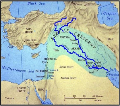
Beginning about 10,000 BCE, nomadic clans began to migrate out of the Taurus, Caucasus, and Zagros Mountains regions and funneled into the mouth of the Tigris and Euphrates Rivers. These two rivers serve a unique purpose to the development of agricultural societies. Historians have deduced that human migration was due to environmental issues. Paleoclimatology scientists believe global warming caused the glaciers and icecaps from the Taurus, Caucasus, and Zagros Mountains to melt. Some researchers believe that clans were pushed from the upper region of Anatolia down into the mouth of the Mesopotamian rivers as floodwaters raised the sea level along the surrounding basins. Other scientists have found evidence that suggests the sea level rose steadily over a long period of time, encroaching on the seminomadic communities and eventually forcing them to relocate.[1]
Mesopotamia in Greek means “between the rivers,” and it did possess two wonderful rivers, called the Tigris and Euphrates. The region spans more than 10,000 square miles and the farthest point between the two rivers is about 150 miles across; the closest point is around 20 miles across. In the early period of settlement along the Tigris and Euphrates Rivers, the soil beds were rich with silt, which provided the necessary nutrients to establish agricultural communities, thus giving the region the name the Fertile Crescent. When the water level rose between April and June, the plains were flooded with enriching silt deposits that made the soil viable for agriculture.
Sumer Region

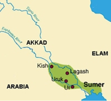
For over a thousand years, the peoples from the north and surrounding regions continued to migrate down the path of the rivers and settle in the lower portion of the Tigris and Euphrates Rivers. In this geographically advantageous area, they were able to successfully transfer and adapt crop techniques, and eventually develop self-sustaining agricultural communities. Humans’ ability to adapt and learn from the past proved to be effective in selecting the settlement area of Sumer. They learned how to survive through observing their surroundings, utilizing the local resources, and working toward common interests. Eventually the transmission of technology helped societies evolve from agricultural communities to advanced civilizations. In the region of Sumer, political, cultural, and religious life became the synergy for close-knit communities, and the cities of Kish, Lagash, Ur, Umma, and Uruk emerged as powerful independent states.
[1]. “Paleoclimatology Data,” National Centers for Environmental Information, https://www.ncdc.noaa.gov/data-access/paleoclimatology-data.

